Germany to see 'extreme heat' and thunderstorms in coming week

With temperatures rising over 30C and little wind, the German Weather Service (DWD) has warned of "extreme heat" in numerous regions around the country on Tuesday and the coming days.
“Even during the nights, it will cool down only slightly in some places,” wrote DWD. “Such heat stress can be dangerous for people. Therefore, you should drink enough water and keep indoor areas as cool as possible.”
Hot and muggy air is currently spreading from the western Mediterranean across Germany, causing sporadic storms predicted to last until Friday, they said.
On early Tuesday morning, eastern Germany already experienced heavy rain and several bursts of thunder and lighting.
READ ALSO: Everything you need to know about staying cool in a German heatwave
What kind of weather can we expect this week?
On Tuesday, DWD said there was a risk of thunderstorms around Germany, excluding the northwest, where temperatures remain cooler. It will be particularly warm in the northeast of the Bundesrepublik, with the mercury reaching up to 34C in cities such as Berlin, Leipzig and Dresden.
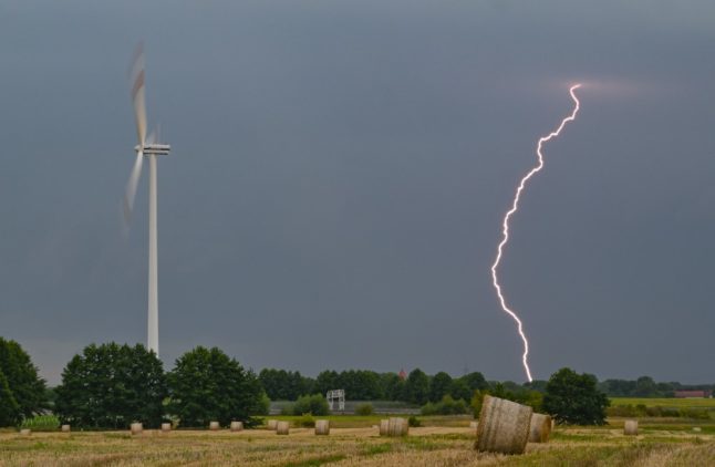
Lightning strikes a field in Jacobsdorf, Brandenburg on Monday. The stormy weather will continue into the week, and be especially severe in the east of the country. Photo: picture alliance/dpa | Patrick Pleul
The thunderstorms will bring heavy rainfall, amounting to 25 to 40 litres per square metre within a short amount of time, wrote DWD, and a possibility of flooding in some areas.
On Wednesday, there will be highs of up to 33C in the south, while it will not get warmer than 23C along the northern coast. Particularly in western Germany, there is a possibility of Platzregnen - the German word for sudden heavy downpours - and thundershowers.
READ ALSO: German word of the day: Platzregnen
The risk of severe weather will stretch into Thursday. Especially in the southern, centre and eastern parts of the Bundesrepublik there are likely to be strong thunderstorms, according to DWD.
The daily highs will range between 23 and 31C, with temperatures somewhat cooler around the North Sea.
‘More summer-like’ weather from Friday
Starting on Friday, the weather will become “more summer-like,” said DWD, bringing mostly clear blue skies and sunshine. Northern Germany could still see some isolated showers and short thunderstorms.
Temperatures will range between 24 and 32C with only light or moderate winds from the east. However, as is typical for bursts of hot and humid weather in Germany, more storms are likely to come in the following week.
This week’s heat wave marks a sharp change from the end of July and early August, when cooler temperatures in the high teens caused some people to lament that summer was already over.
"The full autumn of the past two weeks has disappeared! August is now setting a completely different pace," meteorologist Dominik Jung told the weather service Q.met, describing the current weather situation.
READ ALSO: Rainfall expected in Germany as southern Europe sizzles
Comments
See Also
“Even during the nights, it will cool down only slightly in some places,” wrote DWD. “Such heat stress can be dangerous for people. Therefore, you should drink enough water and keep indoor areas as cool as possible.”
Hot and muggy air is currently spreading from the western Mediterranean across Germany, causing sporadic storms predicted to last until Friday, they said.
On early Tuesday morning, eastern Germany already experienced heavy rain and several bursts of thunder and lighting.
READ ALSO: Everything you need to know about staying cool in a German heatwave
What kind of weather can we expect this week?
On Tuesday, DWD said there was a risk of thunderstorms around Germany, excluding the northwest, where temperatures remain cooler. It will be particularly warm in the northeast of the Bundesrepublik, with the mercury reaching up to 34C in cities such as Berlin, Leipzig and Dresden.
The thunderstorms will bring heavy rainfall, amounting to 25 to 40 litres per square metre within a short amount of time, wrote DWD, and a possibility of flooding in some areas.
On Wednesday, there will be highs of up to 33C in the south, while it will not get warmer than 23C along the northern coast. Particularly in western Germany, there is a possibility of Platzregnen - the German word for sudden heavy downpours - and thundershowers.
READ ALSO: German word of the day: Platzregnen
The risk of severe weather will stretch into Thursday. Especially in the southern, centre and eastern parts of the Bundesrepublik there are likely to be strong thunderstorms, according to DWD.
The daily highs will range between 23 and 31C, with temperatures somewhat cooler around the North Sea.
‘More summer-like’ weather from Friday
Starting on Friday, the weather will become “more summer-like,” said DWD, bringing mostly clear blue skies and sunshine. Northern Germany could still see some isolated showers and short thunderstorms.
Temperatures will range between 24 and 32C with only light or moderate winds from the east. However, as is typical for bursts of hot and humid weather in Germany, more storms are likely to come in the following week.
This week’s heat wave marks a sharp change from the end of July and early August, when cooler temperatures in the high teens caused some people to lament that summer was already over.
"The full autumn of the past two weeks has disappeared! August is now setting a completely different pace," meteorologist Dominik Jung told the weather service Q.met, describing the current weather situation.
READ ALSO: Rainfall expected in Germany as southern Europe sizzles
Join the conversation in our comments section below. Share your own views and experience and if you have a question or suggestion for our journalists then email us at [email protected].
Please keep comments civil, constructive and on topic – and make sure to read our terms of use before getting involved.
Please log in here to leave a comment.