
Residents across Germany woke up to either heavy snowfall or freezing rain on Monday morning, which has hampered rush hour traffic in many cities and caused public transportation disruptions.
You'll want to layer-up in warm, waterproof clothing if you need to go out on Monday or Tuesday.
Drivers should proceed with caution in snowy or icy conditions, and public transport passengers should check ahead for local disruptions before heading out.
Icy roads led to a significant increase in the number of accidents reported in the north-eastern states of Saxony, Brandenburg and Mecklenburg-Western Pomerania on Monday morning.
Freezing rain also created dangerous conditions for pedestrians and cyclists in cities in these areas.
As of 10 am, the German Weather Serivce (DWD) had a number of weather warnings in place, including warnings for slippery conditions in the aforementioned states in the east as well as in Hesse, Baden-Württemberg and southern Bavaria.
There was also a severe weather warning for heavy snowfall in parts of northern Bavaria.
READ ALSO: What drivers in Germany need to know about staying safe in snowy conditions
In the north, there were warnings of strong wind gusts on the North Sea and Baltic Sea coasts and on Heligoland.
The north was also experiencing further snowfall and icy conditions. According to a report by Welt, authorities in Hamburg were looking into tightening enforcement of the obligations to clear ice and snow from walkways.
Tram services cancelled in Berlin
In Berlin, tram traffic was largely stopped from 4 am on Monday morning due to icy overhead lines. BVG announced that tram traffic in the capital city is now suspended indefinitely.
Additionally there were some U-bahn disruptions, such as on the U3 between Breitenbachplatz and Krumme Lanke until the afternoon, and on the U2 between Rosa-Luxemburg-Platz and Pankow as well as between Wittenbergplatz and Potsdamer Platz.
The capital's main roads, however, were gritted and remained passable without problems.
Heavy snow in the south
Snow began falling in the southern parts of Germany on Sunday evening.
Up to 25 centimetres of fresh snow fell in areas around Stuttgart. Around 70 accidents on slippery roads were counted in the evening, according to the German Press Agency (DPA), with a further 50+ in the Ulm region.
Near Weinsberg in Baden-Württemberg, 15 to 20 cars and trucks got stuck in the snow on a road connecting two motorways, police in Heilbronn told DPA.
Around Nuremberg snowfall between five and 15 centimetres was expected, with up to 20 centimetres expected in higher elevation regions nearby.
City bus services were disrupted in Nuremberg and surrounding regions, including in Erlangen and Herzogenaurach, for example.
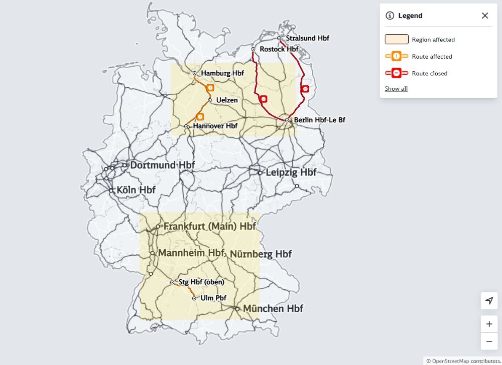
Long-distance railway disruptions
At Deutsche Bahn, delays and train cancellations are to be expected in long-distance traffic, and passengers should check the status of their journey on the website of the DB navigator app before heading out.
At the time of writing, the latest update from Deutsche Bahn said: "Due to winter conditions, there are delays and train cancellations nationwide. Further restrictions are expected in the north [on Monday]."
The Hanover-Uelzen-Hamburg line was affected, due to frozen switches, on Monday morning.
Trains were cancelled between Berlin and Stralsund and Berlin and Rostock and there were restrictions on the Berlin - Hamburg route.
There were additional disruptions in the southwest, especially around Frankfurt and Stuttgart.
Weather forecast
Wintry conditions can be expected to remain in place in much of the country throughout the day on Monday, and then gradually subside.
The largest amounts of snow are expected from eastern Hesse to Upper Franconia, with up to 15 centimetres in many locations.
Inland temperatures are set to remain frosty at freezing to -5C in most places.
IN PICTURES: People in Germany make the most of freezing weather
On Tuesday, weather will remain chilly and overcast in most of the country, with partly sunny conditions expected south of the Danube.
Rain is then expected to move in from the southwest in the afternoon, reaching Germany's central regions by the evening, bringing a risk of black ice, especially in the low mountain ranges.
Highs are expected of between 0 to 7C, with the Upper Rhine region seeing the warmest temperatures.
Tuesday night is expected to bring rain to much of the western half of the country, with snow and partly freezing rain in central regions and in the low mountain ranges.
Similar conditions can be expected through Wednesday.
Comments