On Tuesday morning parts of west Germany were being hit by thunderstorms and heavy rainfall of up to more than 100 litres per square metre in less than 12 hours – enough to flood cellars and city streets.
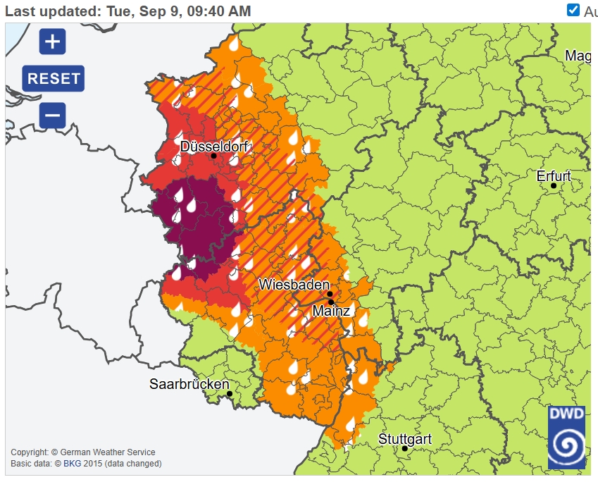
As of around 11am, the highest possible severe weather warning level 4 was in effect in parts of North Rhine-Westphalia and Rhineland-Palatinate, according to the German Weather Service (DWD). The heaviest hit area was specifically around Germany's western border between Aachen and Cologne and extending as far south as the city of Prüm.
In these areas the DWD warned of rapid flooding and possible landslides and "great danger to life and limb".
Experts advised that people "leave their basements immediately" in areas where flooding was expected.
According to German media reports, emergency services had been in continuous operation for several hours in response to the heavy rain and related dangers in North Rhine-Westphalia and Saarland.
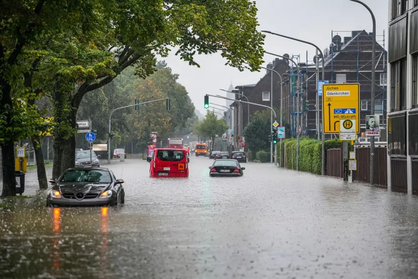
In Mönchengladbach, emergency services had been called more than 70 times by early Tuesday morning, according to a report by t-online. There the fire brigade had freed a family from a flooded apartment and rescued drivers trapped in submerged cars.
According to local police, most emergency calls were in response to flooded cellars and and streets.
The city of Mönchengladbach addressed the parents of school-children in a post online: "In extreme weather conditions, you decide whether the way to school is reasonable for your child." In this case children's absence from school would be excused.
Heftige Regenfälle führen zu teils massiven Überflutungen im Süden von Nordrhein-Westfalen. In den letzten 12 Stunden sind in Bedburg 134 l/qm gefallen. Die Aufnahme zeigt einen überfluteten Straßenzug in Mönchengladbach, vielen Dank an Claudia für die Zusendung. pic.twitter.com/BA8lfQSwte
— Unwetter-Freaks (@unwetterfreaks) September 9, 2025
Also within the area being hardest hit on Tuesday morning are the Eifel region, and the Ahr Valley and parts of Saarland.
The Ahr Valley was at the centre of deadly floods in the summer of 2021. The region's steep and narrow valleys make it a high-risk location when flooding occurs.
READ ALSO: Where in Germany residents have been forced to move by extreme weather
According to initial forecasts, this storm is not expected to be as extreme as the one which caused the flood disaster in 2021.
A police spokesman said weather had remained calm through the night. It began to rain in the Ahr Valley on Tuesday morning.
Tuesday's forecast
Through the day on Tuesday, the DWD expects storms to move from the west to central and southern regions. Thunderstorms and showers can be expected in some places, moving slowly toward the northeast.
Generally, western regions are expected to see the most rain. In Hesse, for example, the weather service predicted up to 50 litres per square metre.
Mild, dry weather is expected in northern and eastern regions of Germany at the start of the day on Tuesday. In the afternoon and evening, scattered thunderstorms may bring heavy rain to places along the Elbe River.
From Western Pomerania to Upper Lusatia, it will remain mostly cloudy or sunny and dry, according to the DWD.
The maximum temperatures will be between 17 and 25C.
Comments