Northern Germany hit by storms and flooding
Weather alerts were issued for northern Germany on Friday as severe gales and torrential rain hit the country.
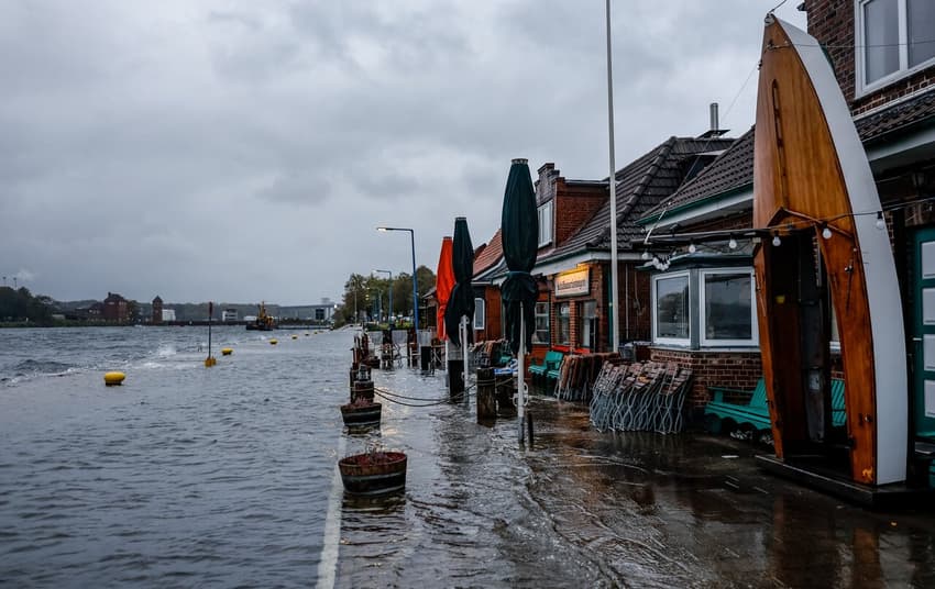
On Friday morning, streets were flooded on the Baltic Sea coast, with affected areas including Wismar, Kiel and Flensburg.
A red 'severe' weather warning was issued by the German Weather Service (DWD) for parts of the Baltic Sea coast including Heligoland and the East Frisian Islands until the early hours of Saturday.
Forecasters said they expected "hurricane-like gusts with speeds of around 110 km per hour".
They urged people to stay inside if possible, warning there was the possibility of trees, branches and other debris being uprooted and blown around.
Schleswig-Holstein's Environment Minister Tobias Goldschmidt (Greens) appealed to coastal residents to be well informed and take appropriate precautionary measures.
An orange weather warning was in place for other parts of northern Germany, where wind speeds of around 70 km/h were expected.
Meanwhile, warnings were also in place in the very south of Germany due to gales in the Alps that were expected to affect valley areas.
Heut brodelt's in der Wetterküche. Etliche Warnungen laufen: In den Alpen kräftiger Föhnsturm mit Durchbruch bis in die Täler. An den Küsten ebenso Sturm mit orkanartigen Böen. Höhepunkt heute Nachmittag bis in die Nacht hinein. Zudem im Norden ab dem Nachmittag Dauerregen. /V pic.twitter.com/Ht5v39XeJW
— DWD (@DWD_presse) October 20, 2023
In Kiel, several beach chairs were pulled into the water in Schiksee on Thursday afternoon. “The water is unusually high there. Around 150 beach chairs were recovered,” said a police spokeswoman.
The storm surge on the Baltic Sea is expected to reach its peak on Friday evening.
On the entire Schleswig-Holstein coast, the water level will rise 1.50 meters or more above normal levels, said a spokeswoman for the Federal Maritime and Hydrographic Agency (BSH) in Rostock.
The hotspot will be the Flensburg Fjord where the water there could rise to 2.00 meters above regular levels by midday Saturday.
“The last time there was such a flood was in 1904,” said Ines Perlet-Markus from the BSH.
READ ALSO: Germany hit by floods as October heat turns into icy spell
Further south and east, water levels will be lower, the spokeswoman said. In Mecklenburg-Western Pomerania, floods will only reach the level of a severe storm surge near the Bay of Lübeck.
According to the DWD, heavy, continuous rain can be expected in Schleswig-Holstein, Hamburg and Lower Saxony. Rainfall amounts of between 25 and 40 liters per square meter are expected in Schleswig-Holstein.
Comments
See Also
On Friday morning, streets were flooded on the Baltic Sea coast, with affected areas including Wismar, Kiel and Flensburg.
A red 'severe' weather warning was issued by the German Weather Service (DWD) for parts of the Baltic Sea coast including Heligoland and the East Frisian Islands until the early hours of Saturday.
Forecasters said they expected "hurricane-like gusts with speeds of around 110 km per hour".
They urged people to stay inside if possible, warning there was the possibility of trees, branches and other debris being uprooted and blown around.
Schleswig-Holstein's Environment Minister Tobias Goldschmidt (Greens) appealed to coastal residents to be well informed and take appropriate precautionary measures.
An orange weather warning was in place for other parts of northern Germany, where wind speeds of around 70 km/h were expected.
Meanwhile, warnings were also in place in the very south of Germany due to gales in the Alps that were expected to affect valley areas.
Heut brodelt's in der Wetterküche. Etliche Warnungen laufen: In den Alpen kräftiger Föhnsturm mit Durchbruch bis in die Täler. An den Küsten ebenso Sturm mit orkanartigen Böen. Höhepunkt heute Nachmittag bis in die Nacht hinein. Zudem im Norden ab dem Nachmittag Dauerregen. /V pic.twitter.com/Ht5v39XeJW
— DWD (@DWD_presse) October 20, 2023
In Kiel, several beach chairs were pulled into the water in Schiksee on Thursday afternoon. “The water is unusually high there. Around 150 beach chairs were recovered,” said a police spokeswoman.
The storm surge on the Baltic Sea is expected to reach its peak on Friday evening.
On the entire Schleswig-Holstein coast, the water level will rise 1.50 meters or more above normal levels, said a spokeswoman for the Federal Maritime and Hydrographic Agency (BSH) in Rostock.
The hotspot will be the Flensburg Fjord where the water there could rise to 2.00 meters above regular levels by midday Saturday.
“The last time there was such a flood was in 1904,” said Ines Perlet-Markus from the BSH.
READ ALSO: Germany hit by floods as October heat turns into icy spell
Further south and east, water levels will be lower, the spokeswoman said. In Mecklenburg-Western Pomerania, floods will only reach the level of a severe storm surge near the Bay of Lübeck.
According to the DWD, heavy, continuous rain can be expected in Schleswig-Holstein, Hamburg and Lower Saxony. Rainfall amounts of between 25 and 40 liters per square meter are expected in Schleswig-Holstein.
Join the conversation in our comments section below. Share your own views and experience and if you have a question or suggestion for our journalists then email us at [email protected].
Please keep comments civil, constructive and on topic – and make sure to read our terms of use before getting involved.
Please log in here to leave a comment.