Major disruption as storm Sabine wreaks havoc across Germany
Serious injuries, transport chaos and storm damage: Sabine is causing huge disruption in Germany.
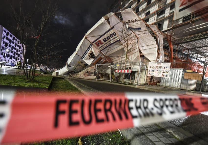
Several people have been injured and there's been major disruption to the transport network due to storm Sabine.
Rail operator Deutsche Bahn halted the long-distance train network in Germany until 10am on Monday, but disruption was expected throughout the day.
In many regions, regional rail traffic is also down. Hundreds of take-offs and landings have been cancelled at airports.
In some parts of the country, including North Rhine-Westphalia, people have been injured by falling trees and flying objects. In southeast Germany "it's all still to come", said a meteorologist of the German Weather Service (DWD) on Monday.
READ ALSO:
-
Deutsche Bahn halts rail services throughout Germany as storm intensifies
-
Germany braces for violent storms and extreme winds
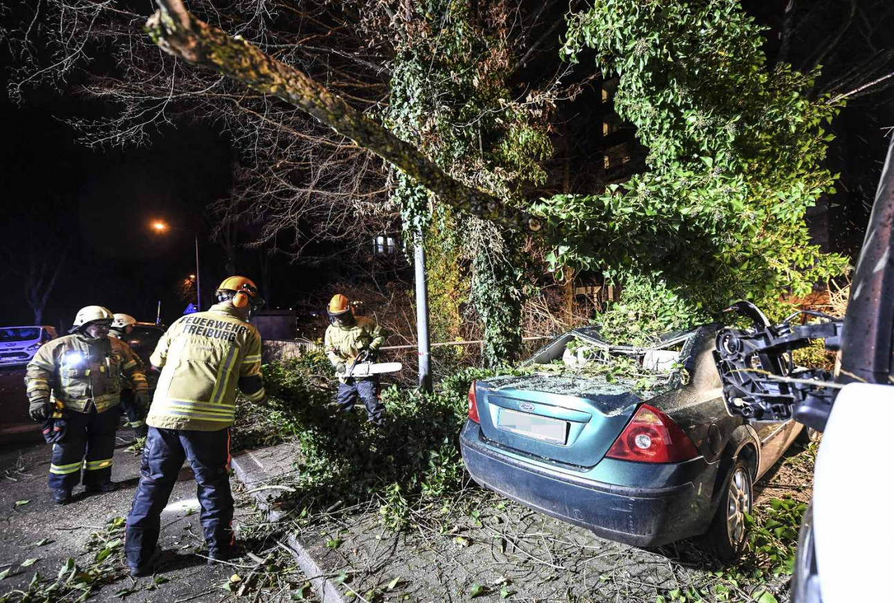 A tree crashed through a car in Freiburg. Photo: DPA
South set to be hit hardest
Sabine, or Ciara as the storm is known in some other parts of Europe, was expected to continue its rampage for several hours throughout Monday.
Meteorologists expected the south of Germany to be hit hardest with strong gusts and heavy rainfall, but it's also still affecting other regions.
According to the DWD, the second highest severe weather warning level applies to the entire southern half of Germany, and the strongest warning is in place for some regions in Baden-Württemberg and Bavaria. "Extreme weather" is to be expected, the DWD said.
"The cold front is currently moving from Saarland via southern Hesse to Thuringia and Berlin," said a meteorologist of the German Weather Service early on Monday morning.
In southern Germany, individual gusts of hurricane force (around 120 km/h) are possible at low altitudes, while on the mountains gale-force wind is possible in some cases (over 140 km/h).
People should expect heavy rain in some areas, and in the middle and south of Germany, there may also be heavy thunderstorms. According to DWD, those who venture outside should be cautious about uprooted trees, falling roof tiles or other objects as well as "widespread severe damage to buildings".
DWD tweeted to say the "cold front" had reached the south and that gale-force winds were still to be expected.
Die #Kaltfront hat den #Süden erreicht. Dort gibt es weiterhin orkanartige Böen und #Orkanböen (100 bis 120 km/h)!
Auch rückseitig der Front bilden sich zahlreiche Schauer und #Gewitter mit teils schweren Sturmböen (um 100 km/h), vereinzelt auch mehr. /V pic.twitter.com/sHxzB0x2cJ
— DWD (@DWD_presse) February 10, 2020
Major transport disruption
Deutsche Bahn (DB) said the storm was causing “considerable disruption” to regional and long-distance services.
“We recommend our passengers postpone long-distance journeys planned for Monday, 10.02.2020 and Tuesday, 11.02.2020 to another day,” said DB on its website.
Tickets purchased for travelling on Sunday to Tuesday remain valid and can be either cancelled or used on other services up until next Tuesday, February 18th.
A free hotline has been set up for customers who want information about the current traffic situation and the effects of the storm on rail traffic. The number is 08000 99 66 33.
Update:#Unwetterschäden:
Der #Bahnverkehr ist am Montag bundesweit beeinträchtigt. Bitte informieren Sie sich regelmäßig auf https://t.co/7JYo1TPRbH bzw. im #DB #Navigator über Ihre Verbindung und die aktuelle Lage. https://t.co/UpsRCUHNoq
— Deutsche Bahn Verkehrsmeldungen (@DB_Info) February 10, 2020
Many regional trains were also at a standstill. For example, all regional trains in Hesse, Rhineland-Palatinate and Saarland were axed on Monday morning.
There's also been lots of cancellations at airports. At North Rhine-Westphalia's two largest airports in Düsseldorf and Cologne, a total of around 150 take-offs and landings were cancelled. Eurowings had cancelled almost all its flights.
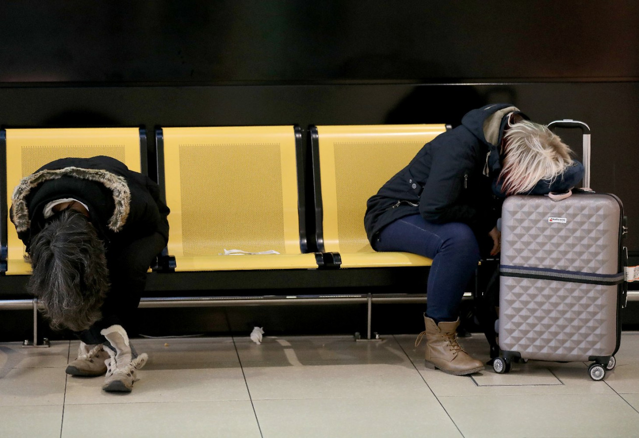 Two passengers trying to sleep in Cologne airport which has been hit by cancellations. Photo: DPA
It’s not only commuters that are affected – many families with school children are also having to make other plans.
Several classes have been cancelled in schools, including in large cities in North Rhine-Westphalia and in parts of Bavaria, Hesse, Lower Saxony and Bremen. The district of Breisgau-Hochschwarzwald has also advised all pupils to stay at home.
Fallen trees cause damage and serious injuries
In almost all of Germany, police control centers reported a large number of fallen trees during the night on Sunday, some of which had fallen onto parked cars.
In Hamburg, the fire brigade was called out about 300 times. On Sunday evening a tree crashed into a detached house, causing the roof and two walls to collapse. Luckily nobody was injured.
Meanwhile, several people were injured in North Rhine-Westphalia. In Mülheim an der Ruhr, two people in a car were very lucky: a 25-meter-high tree crashed into their moving car. One person was injured but not seriously. They were taken to hospital.
"If the car had been in the same place just one second earlier, it could have been much worse," explained the fire department.
In Paderborn, a 16-year-old was seriously injured by a falling branch. He was taken to hospital with head injuries.
Two people in Saarbrücken were seriously injured late Sunday evening by a falling tree. The pedestrians were walking through a parking lot of the Saarbrücken hospital.
There's also been storm damage to the cathedral in Frankfurt am Main after the wind caused a construction crane to crash into the roof of the church during the night.
The storm tide is also affecting the German North Sea coast, Bremen and Hamburg, and Hamburg's famous fish market could also be flooded.
Comments
See Also
Several people have been injured and there's been major disruption to the transport network due to storm Sabine.
Rail operator Deutsche Bahn halted the long-distance train network in Germany until 10am on Monday, but disruption was expected throughout the day.
In many regions, regional rail traffic is also down. Hundreds of take-offs and landings have been cancelled at airports.
In some parts of the country, including North Rhine-Westphalia, people have been injured by falling trees and flying objects. In southeast Germany "it's all still to come", said a meteorologist of the German Weather Service (DWD) on Monday.
READ ALSO:
- Deutsche Bahn halts rail services throughout Germany as storm intensifies
- Germany braces for violent storms and extreme winds
A tree crashed through a car in Freiburg. Photo: DPA
South set to be hit hardest
Sabine, or Ciara as the storm is known in some other parts of Europe, was expected to continue its rampage for several hours throughout Monday.
Meteorologists expected the south of Germany to be hit hardest with strong gusts and heavy rainfall, but it's also still affecting other regions.
According to the DWD, the second highest severe weather warning level applies to the entire southern half of Germany, and the strongest warning is in place for some regions in Baden-Württemberg and Bavaria. "Extreme weather" is to be expected, the DWD said.
"The cold front is currently moving from Saarland via southern Hesse to Thuringia and Berlin," said a meteorologist of the German Weather Service early on Monday morning.
In southern Germany, individual gusts of hurricane force (around 120 km/h) are possible at low altitudes, while on the mountains gale-force wind is possible in some cases (over 140 km/h).
People should expect heavy rain in some areas, and in the middle and south of Germany, there may also be heavy thunderstorms. According to DWD, those who venture outside should be cautious about uprooted trees, falling roof tiles or other objects as well as "widespread severe damage to buildings".
DWD tweeted to say the "cold front" had reached the south and that gale-force winds were still to be expected.
Die #Kaltfront hat den #Süden erreicht. Dort gibt es weiterhin orkanartige Böen und #Orkanböen (100 bis 120 km/h)!
— DWD (@DWD_presse) February 10, 2020
Auch rückseitig der Front bilden sich zahlreiche Schauer und #Gewitter mit teils schweren Sturmböen (um 100 km/h), vereinzelt auch mehr. /V pic.twitter.com/sHxzB0x2cJ
Major transport disruption
Deutsche Bahn (DB) said the storm was causing “considerable disruption” to regional and long-distance services.
“We recommend our passengers postpone long-distance journeys planned for Monday, 10.02.2020 and Tuesday, 11.02.2020 to another day,” said DB on its website.
Tickets purchased for travelling on Sunday to Tuesday remain valid and can be either cancelled or used on other services up until next Tuesday, February 18th.
A free hotline has been set up for customers who want information about the current traffic situation and the effects of the storm on rail traffic. The number is 08000 99 66 33.
Update:#Unwetterschäden:
— Deutsche Bahn Verkehrsmeldungen (@DB_Info) February 10, 2020
Der #Bahnverkehr ist am Montag bundesweit beeinträchtigt. Bitte informieren Sie sich regelmäßig auf https://t.co/7JYo1TPRbH bzw. im #DB #Navigator über Ihre Verbindung und die aktuelle Lage. https://t.co/UpsRCUHNoq
Many regional trains were also at a standstill. For example, all regional trains in Hesse, Rhineland-Palatinate and Saarland were axed on Monday morning.
There's also been lots of cancellations at airports. At North Rhine-Westphalia's two largest airports in Düsseldorf and Cologne, a total of around 150 take-offs and landings were cancelled. Eurowings had cancelled almost all its flights.
Two passengers trying to sleep in Cologne airport which has been hit by cancellations. Photo: DPA
It’s not only commuters that are affected – many families with school children are also having to make other plans.
Several classes have been cancelled in schools, including in large cities in North Rhine-Westphalia and in parts of Bavaria, Hesse, Lower Saxony and Bremen. The district of Breisgau-Hochschwarzwald has also advised all pupils to stay at home.
Fallen trees cause damage and serious injuries
In almost all of Germany, police control centers reported a large number of fallen trees during the night on Sunday, some of which had fallen onto parked cars.
In Hamburg, the fire brigade was called out about 300 times. On Sunday evening a tree crashed into a detached house, causing the roof and two walls to collapse. Luckily nobody was injured.
Meanwhile, several people were injured in North Rhine-Westphalia. In Mülheim an der Ruhr, two people in a car were very lucky: a 25-meter-high tree crashed into their moving car. One person was injured but not seriously. They were taken to hospital.
"If the car had been in the same place just one second earlier, it could have been much worse," explained the fire department.
In Paderborn, a 16-year-old was seriously injured by a falling branch. He was taken to hospital with head injuries.
Two people in Saarbrücken were seriously injured late Sunday evening by a falling tree. The pedestrians were walking through a parking lot of the Saarbrücken hospital.
There's also been storm damage to the cathedral in Frankfurt am Main after the wind caused a construction crane to crash into the roof of the church during the night.
The storm tide is also affecting the German North Sea coast, Bremen and Hamburg, and Hamburg's famous fish market could also be flooded.
Join the conversation in our comments section below. Share your own views and experience and if you have a question or suggestion for our journalists then email us at [email protected].
Please keep comments civil, constructive and on topic – and make sure to read our terms of use before getting involved.
Please log in here to leave a comment.