Storms with gusts upwards of 100km/hour strike Germany
After "Eberhard" struck large parts of Germany over the weekend, a new storm dubbed "Franz" is causing more weather woes and travel chaos.
In the coming days, the weather is likely to stay stormy despite the recovery phases, according to the German Weather Service (DWD) on Wednesday.
SEE ALSO: IN PICTURES: High winds, torrential rain and snow hit Germany
The new storm will spread around Germany, causing showers, thunderstorms, and hail.
(!) Stürmisches #Deutschland - die meisten von Ihnen erleben es gerade. Achten Sie auf #Wettergefahren, informieren Sie sich mit der #Warnwetter-App oder auf https://t.co/c0actryFJD /kis pic.twitter.com/mwYHX058eq
— DWD (@DWD_presse) March 13, 2019
As a precaution, Germany's main rail operator Deutsche Bahn (DB) warned that there could be delays in North Hesse, North Rhine-Westphalia (NRW), Lower Saxony and Schleswig-Holstein.
DB asked travellers to inform themselves in advance about the connections on its website.
According to the DWD, gusts of wind of up to 85 kilometres per hour came to NRW on Wednesday, with heavy gusts of up to 100 km per hour in the mountains. In addition, thunderstorms are expected in many places.
"We expect heavy showers," said a meteorologist. "But it is weaker than what we had on Sunday. The storm should calm down by the evening."
SEE ALSO: Travel chaos as deadly storm strikes Germany
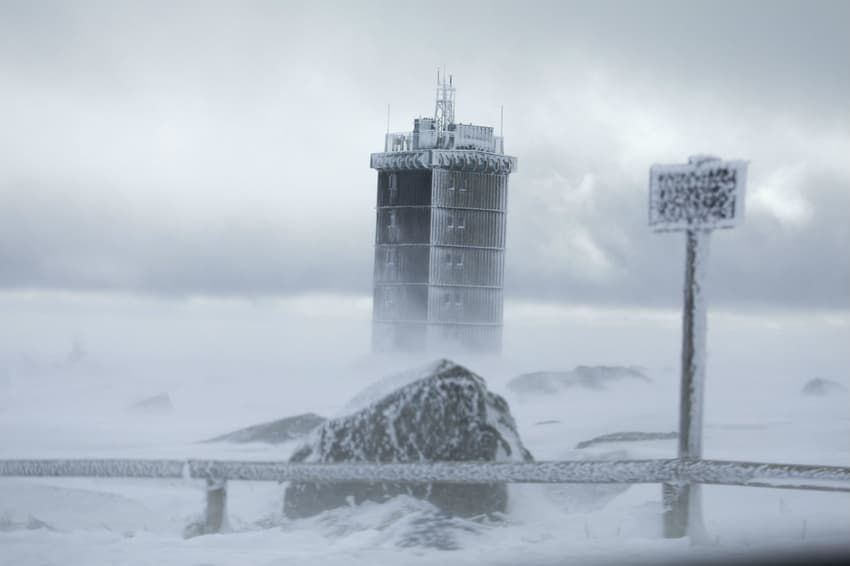
Parts of northeast Germany were met with fierce winds of up to 100 km per hour on Wednesday, as well as a rain and sleet. Brocken in the Herz Mountains in Saxony-Anhalt had winds of 117 km/hour as well as temperatures as low as -4 degrees.
The following graph in a tweet from DWD shows the wind speed in kilometres throughout the country.
Es wird wieder stürmisch! Heute im Tagesverlauf wieder Windzunahme, vor allem kommende Nacht mit Kaltfrontdurchgang gebietsweise vorübergehend stürmisch. Mittwoch verbreitet wieder Sturmböen - anbei eine entsprechende Grafik der erwarteten Böen./V pic.twitter.com/7cret678PM
— DWD (@DWD_presse) March 12, 2019
Calming down as the week goes on
On Thursday, forecasters predict milder temperatures -- with lots of clouds, widespread rain, and the snow starting at 600 metres above sea level.
During the day the snowfall line will rise up to 1000 meters. Within the low mountain ranges, particularly in the Black Forest and Allgäu, it will rain long and persistently. The wind is stormy, in the peaks also hurricane-like.
On Friday it will remain mostly cloudy, with only some slight sun in the east of the country. In the course of the day new rain comes from the west.

A Eurowings flight struggles to land in Hanover on Wednesday due to strong winds. Photo: DPA
Day temperatures are between 7C and 13C degrees. Due to subtropical warm air, it will become warmer over the weekend.
On the Upper Rhine, temperatures of up to 20 degrees may even be reached locally.
However, a cold front on Sunday will ensure that the mercury at the beginning of next week stays in the single digits.
But the strong western current is likely to weaken from Tuesday onwards, "It's possible that the weather will calm down," meteorologist Sebastian Schappert said on Wednesday.
Comments
See Also
In the coming days, the weather is likely to stay stormy despite the recovery phases, according to the German Weather Service (DWD) on Wednesday.
SEE ALSO: IN PICTURES: High winds, torrential rain and snow hit Germany
The new storm will spread around Germany, causing showers, thunderstorms, and hail.
(!) Stürmisches #Deutschland - die meisten von Ihnen erleben es gerade. Achten Sie auf #Wettergefahren, informieren Sie sich mit der #Warnwetter-App oder auf https://t.co/c0actryFJD /kis pic.twitter.com/mwYHX058eq
— DWD (@DWD_presse) March 13, 2019
As a precaution, Germany's main rail operator Deutsche Bahn (DB) warned that there could be delays in North Hesse, North Rhine-Westphalia (NRW), Lower Saxony and Schleswig-Holstein.
DB asked travellers to inform themselves in advance about the connections on its website.
According to the DWD, gusts of wind of up to 85 kilometres per hour came to NRW on Wednesday, with heavy gusts of up to 100 km per hour in the mountains. In addition, thunderstorms are expected in many places.
"We expect heavy showers," said a meteorologist. "But it is weaker than what we had on Sunday. The storm should calm down by the evening."
SEE ALSO: Travel chaos as deadly storm strikes Germany
Parts of northeast Germany were met with fierce winds of up to 100 km per hour on Wednesday, as well as a rain and sleet. Brocken in the Herz Mountains in Saxony-Anhalt had winds of 117 km/hour as well as temperatures as low as -4 degrees.
The following graph in a tweet from DWD shows the wind speed in kilometres throughout the country.
Es wird wieder stürmisch! Heute im Tagesverlauf wieder Windzunahme, vor allem kommende Nacht mit Kaltfrontdurchgang gebietsweise vorübergehend stürmisch. Mittwoch verbreitet wieder Sturmböen - anbei eine entsprechende Grafik der erwarteten Böen./V pic.twitter.com/7cret678PM
— DWD (@DWD_presse) March 12, 2019
Calming down as the week goes on
On Thursday, forecasters predict milder temperatures -- with lots of clouds, widespread rain, and the snow starting at 600 metres above sea level.
During the day the snowfall line will rise up to 1000 meters. Within the low mountain ranges, particularly in the Black Forest and Allgäu, it will rain long and persistently. The wind is stormy, in the peaks also hurricane-like.
On Friday it will remain mostly cloudy, with only some slight sun in the east of the country. In the course of the day new rain comes from the west.
A Eurowings flight struggles to land in Hanover on Wednesday due to strong winds. Photo: DPA
Day temperatures are between 7C and 13C degrees. Due to subtropical warm air, it will become warmer over the weekend.
On the Upper Rhine, temperatures of up to 20 degrees may even be reached locally.
However, a cold front on Sunday will ensure that the mercury at the beginning of next week stays in the single digits.
But the strong western current is likely to weaken from Tuesday onwards, "It's possible that the weather will calm down," meteorologist Sebastian Schappert said on Wednesday.
Join the conversation in our comments section below. Share your own views and experience and if you have a question or suggestion for our journalists then email us at [email protected].
Please keep comments civil, constructive and on topic – and make sure to read our terms of use before getting involved.
Please log in here to leave a comment.