German satellites capture Earth in hi-def 3D
Two German satellites have been orbiting Earth for the last four years mapping the planet's surface to a level 30 times more accurate than anything seen before.
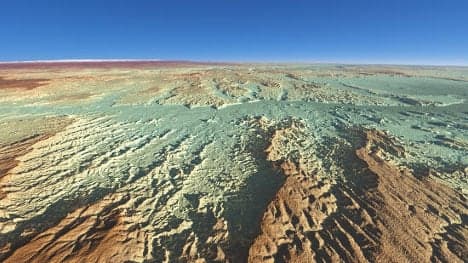
The German Aerospace Centre (DLR) has released the first elevation scans from the project, which has already attracted over 800 scientists from 31 countries to sign up to use the final data when it is released next year.
The two satellites, TerraSAR-X and TanDEM-X, have scanned every inch of the Earth's surface more than twice each, travelling over 800 million kilometres at a height of 514 kilometres above our planet in the first ever precise formation flight between two satellites.
Both satellites mapped the height of points on the Earth's surface by measuring the time it took for radar signals to travel to the ground and back. They are accurate to within one billionth of a second.
CLICK HERE to see some of the images

Alongside constant radar elevation scans, they captured over 350 smaller initial Digital Elevation Models (DEMs), each covering a patch of 30 by 50 kilometres, totalling over 2500 terabytes of data.
And, since the end of 2013, scientists at the DLR have been weaving these pieces together to form a "new topography of Earth," Alberto Moreira, the project's scientific head and director of the DLR's Microwaves and Radar Institute said.
"Due to the significant improvements in accuracy, I am convinced the elevation model… will represent a new reference for a variety of applications," he said.
Researchers started by scanning the "simpler" regions, mostly large flat continental expanses - which need no more than two passes of the satellite to get a 3D image - before moving on to the "difficult" areas like the Alps and Himalayas.
The last phase of scanning data is now being put together, with the project's complete results due to be released in 2015.
And the DLR are considering a follow-up mission which would launch two satellites to scan the Earth's entire surface twice a week - 100 times faster than TerraSAR-X and TanDEM-X – in order to "record the dynamic processes unfolding across Earth".
Such live imaging data would make "an essential contribution to environmental and climate research," according to Moreira.
SEE ALSO: German space centre 'attacked by spies'
Comments
See Also
The German Aerospace Centre (DLR) has released the first elevation scans from the project, which has already attracted over 800 scientists from 31 countries to sign up to use the final data when it is released next year.
The two satellites, TerraSAR-X and TanDEM-X, have scanned every inch of the Earth's surface more than twice each, travelling over 800 million kilometres at a height of 514 kilometres above our planet in the first ever precise formation flight between two satellites.
Both satellites mapped the height of points on the Earth's surface by measuring the time it took for radar signals to travel to the ground and back. They are accurate to within one billionth of a second.
CLICK HERE to see some of the images
Alongside constant radar elevation scans, they captured over 350 smaller initial Digital Elevation Models (DEMs), each covering a patch of 30 by 50 kilometres, totalling over 2500 terabytes of data.
And, since the end of 2013, scientists at the DLR have been weaving these pieces together to form a "new topography of Earth," Alberto Moreira, the project's scientific head and director of the DLR's Microwaves and Radar Institute said.
"Due to the significant improvements in accuracy, I am convinced the elevation model… will represent a new reference for a variety of applications," he said.
Researchers started by scanning the "simpler" regions, mostly large flat continental expanses - which need no more than two passes of the satellite to get a 3D image - before moving on to the "difficult" areas like the Alps and Himalayas.
The last phase of scanning data is now being put together, with the project's complete results due to be released in 2015.
And the DLR are considering a follow-up mission which would launch two satellites to scan the Earth's entire surface twice a week - 100 times faster than TerraSAR-X and TanDEM-X – in order to "record the dynamic processes unfolding across Earth".
Such live imaging data would make "an essential contribution to environmental and climate research," according to Moreira.
SEE ALSO: German space centre 'attacked by spies'
Join the conversation in our comments section below. Share your own views and experience and if you have a question or suggestion for our journalists then email us at [email protected].
Please keep comments civil, constructive and on topic – and make sure to read our terms of use before getting involved.
Please log in here to leave a comment.