Interactive map shows Nazi Blitz on London
A new interactive map online shows the intensity of Nazi Germany's bombing 'Blitz' of London during the Second World War, with geomarkers showing where individual bombs landed.
Created by a geographer from the University of Portsmouth, the website www.bombsight.org takes data from the British National Archives and combines it with geo-tagged photographs from the Imperial War Museum and anecdotes from a BBC wartime memorial project.
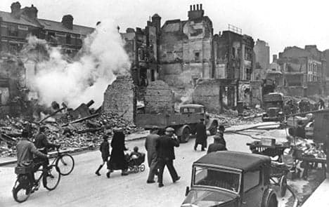
More than 20,000 people died and around 1.4 million Londoners lost their homes in the Nazi bombardment from October 1940 to June 1941.
"It seems astonishing that London survived the onslaught," the project's initiator Kate Jones said in a university statement. "The Bomb Sight project demonstrates the clustering together of lots of different data using the power of geography."
The website allows users to see what the kind of bomb dropped on a particular site, and combines this with pictures and personal details of those affected at the time.
A mobile app for people with Android phones enables people to point their phone at a street scene and get an augmented reality view showing the bombs that were dropped there.
The Local/mry
Comments
See Also
Created by a geographer from the University of Portsmouth, the website www.bombsight.org takes data from the British National Archives and combines it with geo-tagged photographs from the Imperial War Museum and anecdotes from a BBC wartime memorial project.
More than 20,000 people died and around 1.4 million Londoners lost their homes in the Nazi bombardment from October 1940 to June 1941.
"It seems astonishing that London survived the onslaught," the project's initiator Kate Jones said in a university statement. "The Bomb Sight project demonstrates the clustering together of lots of different data using the power of geography."
The website allows users to see what the kind of bomb dropped on a particular site, and combines this with pictures and personal details of those affected at the time.
A mobile app for people with Android phones enables people to point their phone at a street scene and get an augmented reality view showing the bombs that were dropped there.
The Local/mry
Join the conversation in our comments section below. Share your own views and experience and if you have a question or suggestion for our journalists then email us at [email protected].
Please keep comments civil, constructive and on topic – and make sure to read our terms of use before getting involved.
Please log in here to leave a comment.